Below you will find a list of questions frequently asked of the Land Planning and Engineering Departments. These FAQs are meant to be a guide and are currently under construction. If your questions are not answered below, or if you require more specific information, please contact the Big Horn County Land Planning Department or Engineering Department. We recommend that you contact us before commencing with any development projects (e.g., construction, improvements, septic installation, etc.) just to be on the safe side.
FAQ Topic 1 : Access and Roads
Do I need permission to develop an access road to my property from a county road?
If there is an existing, in-use access you should check with the Engineering Department.
If the access you are requesting will be newly constructed and intersects any county road, you will need to complete an Right of Way Permit Application through the Engineering Department. The applications are free and the Engineering staff will assist you in completing the application. Access Permits require an onsite review prior to approval and an onsite review following construction. The permit is approved when the County Engineer and the County Commissioners sign the application. This process typically takes 2-3 weeks.
When does the county name a road?
County roads are named and given an official county road number when they are approved by the County Commissioners as county roads. For legal names of county roads, contact the Engineering Department. For information about the naming of subdivision or private roads, contact the Land Planning Department.
Who names the new roads?
The Engineering Department and County Commissioners name any new, unnamed road that is adopted into the county’s roadway system. For information about the naming of subdivision or private roads, contact the Land Planning Department.
How do I find out who owns a road?
Road research requests are performed by the Engineering Department. To determine the exact legality of a road, you may contact the Engineering staff. Road records are retained in the County Engineer’s office. The public may research records during regular business hours.
How do I find the right-of-way for a County Road?
Road research requests are performed by the Engineering Department. To determine right-of-way of a road, contact the Engineering staff. Additionally, road records are retained in the County Engineer’s office. The public may research records during regular business hours.
How do I report a missing or damaged road sign?
To report a down, missing or damaged sign, contact the Engineering Department at 307-568-2467 or send an email to engineering@bighorncountywy.gov.
FAQ Topic 2 : Addressing
How do I get an address?
If the location you are seeking an address for is within a municipal boundary (i.e., Basin, Burlington, Byron, Cowley, Deaver, Frannie, Greybull, Lovell or Manderson), please contact the appropriate municipality. In order to get an address in unincorporated Big Horn County, you must submit an Address Application and fee to the Land Planning Department. The Land Planning staff will review your application, assign an address and contact you (and any appropriate agencies) with your new address. As soon as possible, a fire address marker (red sign with white numbers) will be placed at the access to your addressed site to assist with emergency response.
How is the address number determined?
If the address location is on a currently named road, the address number will be assigned based on a number range defined by the Big Horn County Address System. Using geographic information systems (GIS), the road will be segmented into sections that match the range of numbers defined. In most cases, the address number assigned will be chosen where the access road to the address location meets the named road. Generally, addresses north or east of the named road will have an odd number assigned and addresses south or west of the named road will have an even number assigned.
If the address location is on an unnamed road and there are two or less addressed locations along the access, a number will be assigned based on the named road that the access road intersects. If the address location is on an unnamed road and there are three or more addressed locations along the access, the private road will first be named using the process defined in the Big Horn County, WY, Rural Addressing Policy, then all addresses along the road will be reassigned accordingly.
Can my address be changed?
There are occasions where addresses are modified. One example is when more than two residences share a common access road that has not yet been named. In this case, the road will be named and any existing addresses along the road will be changed to match the newly named road. Each addressee will be notified of the change, as well as all emergency services and dispatch offices, utility companies, county offices, the postal service, and other interested parties.
If an existing address does not conform to the County address system or policy, the County Planner will initiate the process for changing an address.
See the Big Horn County, WY, Rural Addressing Policy for more information.
How do I report an address sign missing or down?
To report a down, missing or damaged sign call the Land Planning Department at (307) 568-2424 or send an email to planner@bighorncountywy.gov.
FAQ Topic 3: Building and Development
Where can I find the building codes for Big Horn County?
Big Horn County does not have any building codes for development in unincorporated areas. However, if you wish to sell your property in the future, we recommend that you use a national building code standard for any improvement projects. For development within town limits, please contact the appropriate municipality to determine if they have special building codes or requirements.
What am I required to do before I build on or alter my property?
Before construction, you must submit a Development Application and fee to the Land Planning Department. The staff will review each submission to ensure that planned activities are in accordance with any land planning or zoning regulations or ordinances (e.g., Flood Damage Prevention Regulation for Big Horn County or Big Horn County Airport Area Zoning Regulations). If the planned development is found to occur in an area with special requirements, an additional permit may be required before construction can commence.
How do I get utilities to my property?
Refer to Faq Topic 10: Utilities
I want to put a fence up on my property. Are there any special requirements for fences in Big Horn County? Big Horn County does not have any building codes for parcels in unincorporated areas. We do recommend that you conduct a thorough review of any deeds and/or surveys for your parcel and any adjacent parcels whose boundary lines may come into question upon fence construction. If no survey exists, we strongly recommend that you obtain a survey for your property before commencing with construction. Also, if the area you want to fence is within a floodplain, you must contact the Land Planning Department before proceeding with the work.
What is required to drill a well on my property?
See Faq Topic 12:Wells.
Where can I find snow load information?
Big Horn County does not have requirements for snow loads. However, the US Forest Service provides links to information that can help developers estimate snow load amounts.
FAQ Topic 4: Flooding and Flood Risks
NOTE: Please refer to the Flood Damage Prevention Regulation for Big Horn County for Big Horn County or call the Land Planning Department before beginning a project. These Frequently Asked Questions are meant to be a guide, but are not the regulations.
What is a flood?
According to the Federal Emergency Management Agency (FEMA), “A flood is a general and temporary condition where two or more acres of normally dry land area or two or more properties (at least one of which is your property) from overflow of inland or tidal waters, from unusual and rapid accumulation or runoff of surface waters from any source, or from mudflow.”
Is flooding a problem in Big Horn County?
Several areas in Big Horn County are at risk of flooding, based upon historic events. To identify our community’s flood risk, the Federal Emergency Management Agency (FEMA) conducted a Flood Insurance Study. The data compiled during that study was used to create Flood Insurance Rate Maps (FIRMS), which provide an official depiction of flood hazards for properties within each community.
How do I find out if my property lies within a flood hazard area?
To see if your property lies within a flood hazard area, you can view digital copies of the FIRMs online. Also, the Land Planning Office has a hardcopy set of the FIRM panels, as well as a digital version. If you have questions about areas designated as flood hazard areas in unincorporated Big Horn County, you may contact the County Planner at 307-568-2424.
What should I do if my property is in a flood hazard area and I want to make improvements?
If your property is located within a mapped flood hazard area and you are planning to make changes (such as excavation or construction), you will need to fill out an Application for a Floodplain Development Permit through the Land Planning Department.
Am I eligible for flood insurance?
Unincorporated Big Horn County participates in the NFIP, a program that provides means for property owners to financially protect themselves from flood risks. If you are a homeowner, renter, or business owner in unincorporated Big Horn County, flood insurance coverage options from the NFIP are available to you whether your property lies within a flood hazard area or not.
Several towns within Big Horn County also participate in the NFIP: Basin, Greybull, Lovell and Manderson. However, the towns of Byron and Cowley do not participate in the NFIP.
Can I contest whether or not my property is in a designated flood hazard area?
The owner of the property can petition FEMA for a “Letter of Map Revision” where the property will be evaluated more extensively to see if an error is present. FEMA provides an explicit appeal procedure online.
FAQ Topic 5: GIS Data and Maps
What is GIS?
GIS stands for “geographic information systems.” The concept ties geography (LOCATION) and information (DETAILS AND FACTS) about different locations together into a digital mapping system display. More information about the concept of GIS can be found on our GIS page.
How can I find a map of parcels in Big Horn County?
Visit our MapServer.
Are digital data layers available for purchase?
Several GIS data layers are available for purchase. Please contact the Land Planning Department for details and our fee schedule. Data requests cannot be fulfilled until a Data Sharing Agreement is signed and submitted with payment.
FAQ Topic 6: Legal Records and Surveys
Where can I find a copy of the deed or legal description for property in Big Horn County?
The County Clerk’s office holds all official land records for the county.
How can I find out if my land has been surveyed in the past?
If a land survey was conducted, it is possible (but not guaranteed) that the survey was filed with the County Clerk’s office. If a survey was conducted but not recorded, it is possible that a local surveying/engineering firm did the work. You may want to try contacting them to see if they have anything on record. The Land Planning Department does not keep official records of any surveys; however we often keep copies of survey plats provided during the subdivision process.
FAQ Topic 7: Minerals, Gas and Oil
Does the Land Planning Department have information about geologic studies or exploration done related to minerals, gas and/or oil?
No. The Land Planning Department does not have this type of information. Refer to the Wyoming Oil and Gas Commission or the Department of Interior, Bureau of Land Management EPA and DEQ.
Where can I find information about mineral rights and oil and gas leases in Big Horn County?
The County Clerk’s office holds information regarding mineral rights and oil and gas leases for private lands in unincorporated Big Horn County. For publicly owned lands, contact the appropriate agency (e.g., BLM, Forest Service, etc.).
FAQ Topic 8: Septic Permits
NOTE: Please contact the Land Planning Department before beginning a project. These Frequently Asked Questions are meant to be a guide, but are not the regulations.
What is a septic/wastewater permit?
A septic permit is a written authorization issued by the county, which authorizes the applicant to construct, install, repair or modify a small wastewater system. A small wastewater system is any sewage system, disposal system or treatment works designed to discharge less than two thousand gallons of domestic sewage per day.
Where can I get an application for a septic permit?
The Septic Permit Application Package can be found on our website or can be picked up at the Land Planning Department. Please note that this is a workbook - you only need to submit the first couple of pages to get the process started.
Who can I contact if I have any questions about the application?
For any questions regarding septic permit applications for an existing system or a proposed system, please contact the Land Planner at (307) 568-2424.
Who can install wastewater systems in Big Horn County? Can I install my own wastewater system?
Once approval to construct is granted, property owners may hire a contractor to do the system installation for them or they may install their own system under the guidance of the county Land Planning Department.
How do I determine the size of my wastewater system?
The wastewater system is determined by the number of bedrooms in the structure, as well as other criteria. For more complete requirements, please schedule an appointment with the Land Planner (307-568-2424).
When can I begin putting the system in?
Permission to install, repair or modify a system will not be granted until the applicant’s application and fee have been received and reviewed by the Land Planning Department. We will contact the applicant as soon as possible after review of the application is complete. If permission to construct is given, the installer may begin work. The installer cannot backfill until the Land Planning Department has visited the site and given final approval of the system.
FAQ Topic 9: Subdivisions
If you are planning to subdivide your land, we strongly recommend that you contact the Land Planning Department before proceeding with any survey work, deed recordings or sales agreements. There are many exceptions to the rules and we most certainly want to help you conduct a legal subdivision of your land.
What is a subdivision?
A subdivision is the creation or division of a lot, tract, parcel or other unit of land for the immediate or future purpose of sale, building development or redevelopment for residential, recreational, industrial, commercial or public uses.
Do I need permission to subdivide my land?
The Subdivision Regulations govern the subdivision of land within unincorporated Big Horn County. These regulations were developed pursuant to Wyoming State Statutes (W.S. 18-5-301 through 18-5-315). While several types of subdivisions may be exempt from the regulations (e.g., family exemption, large-acreage exemption, boundary line adjustments…), others fall under the categories of “Simple Subdivision” and “Major Subdivision.” These types of subdivisions require applicants to work with the Land Planning Department to complete the processes outlined in the regulations. Exempt subdivisions and simple subdivisions are most common in Big Horn County at this time. Please contact the Land Planning Department if you have any questions regarding subdivisions. If your property lies within a town boundary, please contact the appropriate municipality.
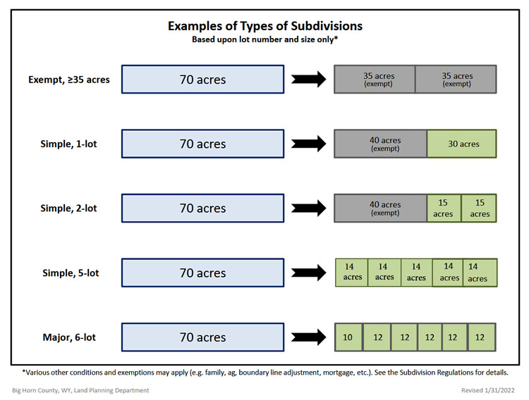
What is the difference between an exempt subdivision, a simple subdivision and a major subdivision?
While there are several reasons that a subdivision could be exempt from the subdivision regulations, we’ll focus this example on lot size alone. If a landowner splits his/her parcel into pieces that are each 35 acres or larger, the subdivision is exempt and the landowner is not required to go through the subdivision process. However, and exempt subdivision requires an Affidavit of Exemption to be filled with the Surveyor's Final Plat. Please contact the Land Planning Department for the Application for Exempt Land Division.
A simple subdivision is a division of one unit of land (a parcel) into one or two lots smaller than 35 acres each. The most common example of a Simple Subdivision is when a person wants to break off a portion of their parcel to sell it to someone else. Let’s say the parcel is currently 70 acres and the owner wants to sell a 30-acre piece of it. In essence, a 40-acre parcel and a 30-acre parcel are being created. The 40-acre parcel is exempt from the regulations because it is 35 acres or larger. However, the 30-acre parcel is not. Therefore, the landowner would be required to go through the formal subdivision process before he/she would be able to sell the 30-acre parcel.
If the same landowner chose, instead, to split the 70-acre parcel into more than 5 lots, it would be considered a Major Subdivision (subdividing one unit of land into more than 5 lots, each smaller than 35 acres). See an example of types of Subdivisions in graphic below.
How long does it take to complete the simple subdivision process?
In the simplest of cases, it takes approximately 90 days to complete a simple subdivision. The timeline can be affected by numerous things, for example: Time required by the Land Planning Department for review; time required to contact adjacent landowners and notify the public; time required for conservation and fire district review of the application; time required for town review (if applicable); time required for Planning and Zoning Commission review and time required for review by the Board of County Commissioners. For various reasons, any of these steps in the process could be delayed, thus extending the time required to complete the process.
FAQ Topic 10: Utilities
How do I get utilities to my property?
Contact the local utility provider for gas, electric, water, irrigation or telephone services. The provider is required to submit a Right of Way Permit Application and fee to the Engineering Department if the establishment of any new service will require any work in the right-of-way of a county road. After review, the application is taken to the County Commissioners for final permit approval. The Commissioners meet every 1st & 3rd Tuesday of every month. Most utility providers now require you to have an approved physical address for the site where you wish to be served.
FAQ Topic 11: Water Rights and Irragation
How do I find out if water rights exist on a particular plot of land?
Check the records in the County Clerk’s office or through the Wyoming State Engineer's Office. The records should indicate the appropriation amount, priority of the right and how and where the water is to be used. The Wyoming State Engineer’s Office is charged with the regulation and administration of the water resources in Wyoming. The granting of a water right by the state engineer does not include the granting of ditch easements and rights of way. You must negotiate these with the affected landowners.
Am I required to get a permit to create a new ditch to divert water from a stream on my property?
New water diversions from streams, including ditches and pipelines, require an application be submitted the Wyoming State Engineer’s Office (SEO) Surface Water Division. The same is true if you want to enlarge an existing ditch or pipeline.
Am I required to get a permit to construct or enlarge a reservoir?
An application from the Wyoming State Engineer's Office is required to permit construction or enlargement of reservoirs.
FAQ Topic 12: Wells
Am I required to get a permit to drill a ground water well on my property?
Before you drill a well that will be used for domestic and/or stock use, you must submit an application for a permit to the Wyoming State Engineer’s Office (SEO), Ground Water Division. Copies of the form can be downloaded from the Wyoming SEO website or picked up at the Land Planning Department. Please make sure that you DO NOT FOLD the application when mailing it.
Credits
Portions of the information provided above came from the following sources:
• Albany County, Wyoming, Frequently Asked Questions
• Wyoming Department of Environmental Quality
• Wyoming State Engineer’s Office
• “Wyoming Water Law: A Summary” by James J. Jacobs, Gordon Fassett, and Donald J. Brosz, B-849R, June 1995, Cooperative Extension Service, College of Agriculture and Wyoming Water Research Center University of Wyoming.